
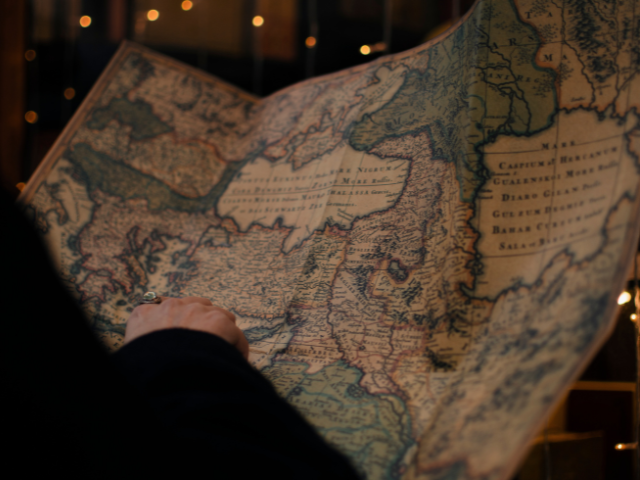
GIS is waking up the world to the power of geography, this science of integration, and has the framework for creating a better future.
Jack Dangermond
Quick Service Request
Connect With Our Expert Team

About Company
R- Geo Solution
R Geo Solution is a rapidly growing startup specializing in GIS-based services for government and commercial clients. Founded in 2021, we prioritize quality, timely data delivery, and client satisfaction.
Our expertise includes GIS data mapping, drone-based data processing, data collection, and surveying for over 50 companies. Committed to innovation and development, we strive to make a positive impact while protecting the environment. With a focus on trust and honesty, we empower individuals to thrive in global industries. Our team fosters a supportive environment where each member can advance their skills and knowledge.
- Certified Company
4
Years In Business
48
Happy Clients
62
Projects Completed
30
Trained Staff
Our Services
We Offer Superior GIS Solutions
GIS Data Mapping
R Geo Solution. We specialize in providing high-quality GIS Data Mapping services, translating complex data into visually compelling and actionable maps for a wide range of applications.
Read more
Our Services:
1.Spatial Analysis:
1.Expert interpretation of spatial data to derive meaningful insights.
2.Uncover patterns, trends, and relationships for informed decision-making.
2.Custom Mapping Solutions:
1.Tailored maps designed to meet the unique needs of diverse industries.
2.From thematic maps to custom overlays, we deliver visualizations that matter.
Applications Across Industries:
- Environmental Monitoring: Comprehensive mapping for tracking and analyzing environmental changes.
- Urban Planning: Optimize city layouts and infrastructure with detailed urban maps.
- Infrastructure Management: Visualize and manage infrastructure assets efficiently with GIS mapping.
- Natural Resource Planning: Detailed mapping for sustainable management of natural resources.
- Emergency Response: Precise mapping to facilitate quick and effective emergency response planning.
- Location Intelligence: Utilize spatial insights for strategic business decisions and market analysis.
Why Choose R Geo Solution:
- Expert Cartographers: Our skilled cartography team ensures visually appealing and accurate maps.
- Cutting-Edge Technology: Utilizing the latest GIS tools and technology for mapping excellence.
- Data Integration: Seamless integration of diverse datasets for comprehensive mapping solutions.
- Client-Centric Approach: Customized mapping solutions tailored to meet specific project requirements.
Choose R Geo Solution for GIS Data Mapping services that go beyond conventional maps, providing you with the spatial intelligence needed to drive success in your projects. Experience precision, customization, and excellence in every map we create.
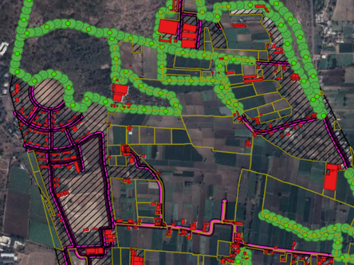
GIS Data Digitization
R Geo Solution specialize in delivering top-notch GIS Data Digitization services, seamlessly transforming analog information into accurate and actionable digital datasets for informed decision-making.
Read more
Our Services:
1.Data Digitization:
1.Precise conversion of analog maps, plans, and documents into digital GIS formats.
2.Ensuring the integrity and completeness of digitized geographic information.
2.Attribute Data Capture:
1.Capturing and organizing attribute data to enhance the richness of GIS databases.
2.Facilitating detailed analysis and comprehensive spatial insights.
Applications Across Industries:
- Land Management: Optimize land use and resource planning with efficient mapping and analysis.
- Infrastructure Planning: Accurate GIS data for effective planning and management of infrastructure projects.
- Environmental Studies: Comprehensive datasets for environmental monitoring and analysis.
- Utilities Management: Streamlined management of utility networks through accurate digitization.
- Urban Development: Informed decision-making with detailed GIS data on urban landscapes.
- Emergency Response Planning: Quick and effective response planning with accurate spatial information.
- Natural Resource Mapping: Sustainable resource management through detailed mapping of natural resources.
Why Choose R Geo Solution:
- Expert Team: Our skilled professionals bring extensive experience, ensuring the highest quality in GIS data digitization.
- Tailored Solutions: Customized approaches to meet the unique needs of diverse industries and projects.
- Cutting-Edge Technology: Utilizing the latest tools and techniques for accurate and efficient digitization.
- Data Integrity: A commitment to delivering digitized data with the utmost accuracy and reliability.
Choose R Geo Solution for GIS Data Digitization services that redefine precision and efficiency in handling geographic information. Experience the seamless transformation of analog data into actionable digital insights with our commitment to excellence.

Drone Data Processing
At R Geo Solution, we specialize in delivering cutting-edge Drone Data Processing services, transforming raw aerial imagery into actionable insights for a multitude of industries.
Read more
Our advanced technology and experienced team ensure the creation of comprehensive orthomosaics, unlocking a range of valuable data outputs.
Our Services:
1.Orthomosaic Creation:
1.Seamless merging of drone images for accurate georeferenced orthomosaics.
2.Providing a detailed and cohesive visual representation for in-depth analysis.
2.Data Outputs:
1.Digital Terrain Model (DTM)
2.Digital Surface Model (DSM)
3.Digital Elevation Model (DEM)
4.3D Images
5.Contours
Applications Across Industries:
- Land Surveying: Precise land measurements and boundary assessments.
- Property Survey: Comprehensive property assessment through detailed aerial perspectives.
- Urban Planning: Optimal planning and analysis of urban spaces.
- Land Management and Development: Streamlined land development projects with insightful data.
- High-Resolution Imaging and 3D Mapping: Stunning visuals for enhanced visualization and analysis.
- Slope Monitoring: Real-time slope data for safety and stability.
- Construction: Detailed site analysis for optimized construction processes.
- Agriculture: Improved crop management through accurate field mapping.
- Mining: Enhanced resource exploration and management with detailed aerial surveys.
- Industrial Plant and Energy: Monitoring infrastructure for optimal energy projects.
- Transportation: Planning and analyzing transportation routes and infrastructure.
Why Choose R Geo Solution:
- Expertise: A skilled team with a wealth of experience in optimal data processing and analysis.
- Tailored Solutions: Understanding and addressing the unique needs of each industry.
- Cutting-Edge Technology: Staying ahead with the latest advancements in drone mapping technology.
- Comprehensive Insights: Unlocking a wealth of actionable insights to drive informed decision-making.
Choose R Geo Solution for Drone Data Processing services that redefine precision, efficiency, and innovation. Elevate your projects with our commitment to delivering superior aerial datasets and valuable insights.
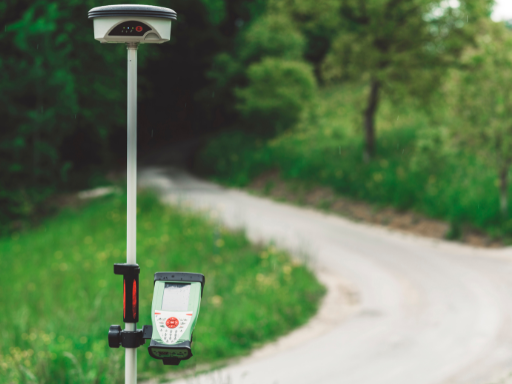
Surveying & Data Capturing
At R Geo Solution, we specialize in providing comprehensive Surveying & Data Capturing services, leveraging state-of-the-art technologies to ensure accuracy and reliability. Our skilled team of surveying
Read more
professionals utilizes a combination of DGPS (Differential Global Positioning System), GPS (Global Positioning System), and Total Station Survey methods to meet the diverse needs of our clients.
Our Services:
1.DGPS (Differential Global Positioning System):
- High-precision positioning
- Real-time corrections for enhanced accuracy
- Ideal for large-scale surveys and mapping
2.GPS (Global Positioning System):
- Satellite-based navigation for accurate location determination
- Versatile applications in various surveying projects
3.Total Station Survey:
- Optical instrument for precise angle and distance measurements
- Comprehensive data capturing for land surveying and construction layout
Additional Services
We Also Offer
At R-Geo Solution, we also offer professional land surveying, cartography, and GIS development services to complement our core offerings. Our expertise in remote sensing and mapping further enhances our comprehensive GIS solutions. Explore our full range of geospatial services for a complete solution tailored to your needs.
- GIS Data Extraction
- GIS Data Analysis
- Change Detection
- LiDAR Data Processing
- 3D Modeling

Why Choose Us
Six Reasons For People Choosing Us
Expertise
A skilled team proficient in GIS for precise analysis
Comprehensive Solutions
A complete range of GIS services for businesses' needs
Innovative Approach
Utilizing advanced GIS technology for strategic decision-making
Industry Focus
Tailoring GIS solutions to meet the diverse needs of industries
Data-Driven Decisions
Smart insights derived from comprehensive GIS data analysis
Customer Satisfaction
High-quality service with a focus on client satisfaction and results
We Are Business Who Cares, And it Shows
4.9-Star Google Rating and Climbing with Many 5-Star Reviews
Rate Us on Google
4.9 star ratings

Follow Us on LinkedIn
2k+ Followers
People Say The Nicest Things
Discover What Our Clients Are Saying and Explore the Praise They've Shared.

★★★★★ Rated 4.5 out of 5
Rahul Bakare
Director at Urdhvam Environmental Tech Pvt Ltd
R-Geo Solution’s GIS expertise has transformed our operations. Their top-tier solutions have been instrumental in our success, and we highly recommend them!

★★★★★ Rated 4 out of 5
Sachin Joshi
Director of Operations at Altrix Tech Pvt Ltd
Working with R-Geo Solution has been a game-changer for us. Their unmatched dedication and professionalism have made them a trusted partner, and we look forward to continuing our successful collaboration.

★★★★★ Rated 4.5 out of 5
Dr.Shweta Rai
Co-Founder at JatayuGeo Technologies
Choosing R-Geo Solution was one of our best decisions. Their expertise and commitment have made them invaluable to our success, and we highly value our partnership with them.
Looking to Begin Your GIS Journey?
Get Solutions for All Your GIS Needs
Offices
Head Office
Our head office is in Pune, ready to serve you with our expertise.
02,ABC Nirman Building, Thergaon,pimpri-chinchwad Pune – 411 033, Pune, Maharashtra 411033
Email: info@rgeosolution.com